

For decades, rumor mills have blamed wild magnetic forces for spinning ship compasses out of control inside the Bermuda Triangle. Popular lore insists a localized magnetic vortex pulls vessels off course and straight into the ocean abyss. The real explanation comes down to basic navigational physics, Earth’s shifting magnetic field, and a harmless line known as the Agonic Line.
The myth of the “Magnetic Vortex”
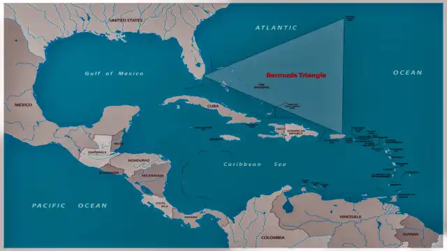
Step into any book on urban legends, and you will hear a dramatic tale about the Bermuda Triangle. Planes fly through eerie clouds. Ship dials spin erratically like possessed toys. Radio operators scream into dead airwaves before vanishing forever.
Is there any physical proof that a magnetic anomaly lurks under the Atlantic ocean floor?
Scientists at the National Oceanic and Atmospheric Administration (NOAA) have surveyed the region for generations. Their answer is simple: no localized magnetic anomaly exists in the Bermuda Triangle.
Geologists use sensitive instruments called magnetometers to map Earth’s crustal magnetic fields. Certain places on Earth do contain massive deposits of iron ore or volcanic basalt that distort magnetic compasses locally. The Kursk Magnetic Anomaly in Russia is a famous example. The Bermuda Triangle has no such iron deposits underneath its seabed.
Where did the spinning compass myth come from? It turns out people confuse magnetic anomalies with routine magnetic variation.
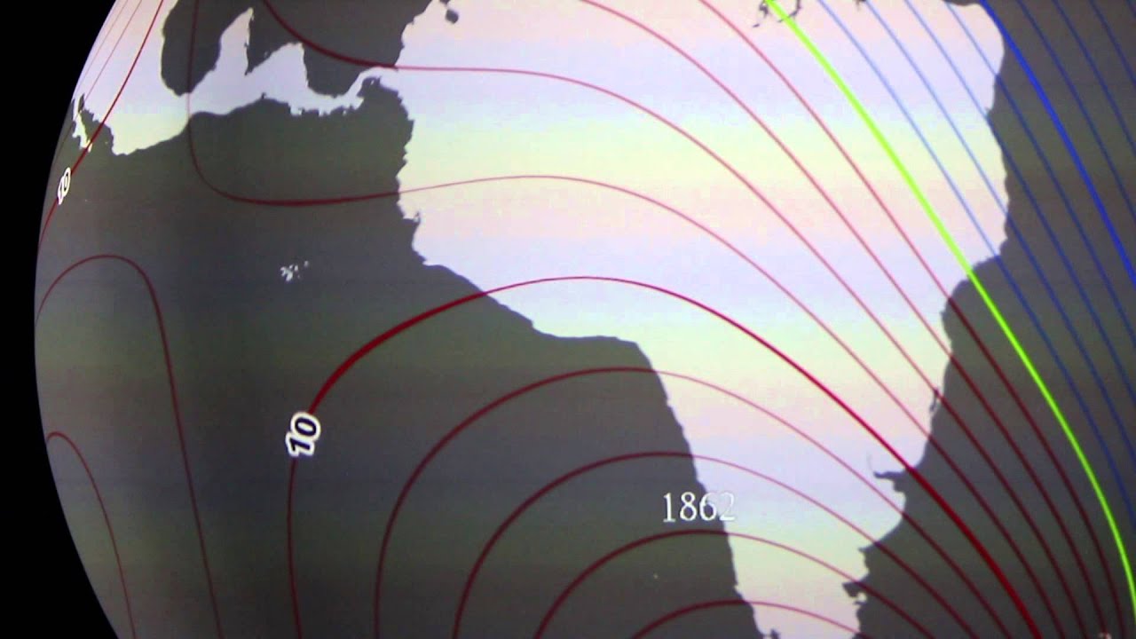
True North vs Magnetic North: what your compass actually sees
To understand why compasses behave weirdly on open waters, you need to understand how our planet magnetizes space.
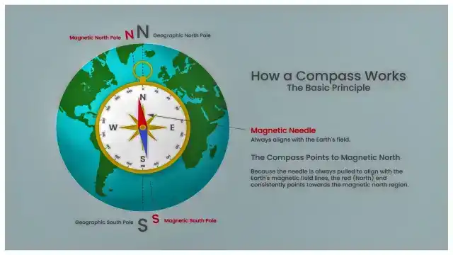
Earth acts like a giant bar magnet tipped at an angle. It gives us two distinctly different “Norths”:
- True North (Geographic North): The fixed geographic location of the North Pole where lines of longitude converge. It marks the rotational axis of Earth.
- Magnetic North: The spot on Earth’s surface where the magnetic field lines point straight down into the ground.
Magnetic North is not a static point on a map. Fluid iron churns continuously thousands of miles deep inside Earth’s liquid outer core. That churning motion causes Magnetic North to wander across the Arctic tundra at speeds of up to 30 miles per year.
Because True North and Magnetic North are in two completely different places, a magnetic compass needle almost never points to the real Geographic North Pole.

The angular difference between True North and Magnetic North at any specific location is called magnetic declination (mariners often call it magnetic variation).
If you stand in Seattle, your magnetic compass might point 15 degrees East of True North. Stand in Maine, and it points 14 degrees West of True North. Skippers and pilots must manually adjust their calculations for these offset angles to avoid drifting off course.
Agonic line: true culprit behind historic navigation errors
What happens when magnetic declination drops to zero? You hit an agonic line.
An agonic line is an invisible contour line running across Earth where Magnetic North and True North happen to align perfectly from your point of view. Stand right on the agonic line, and your compass needle points directly at both True North and Magnetic North at the exact same moment.
| Feature | Description |
|---|---|
| Magnetic North | Arctic Canada |
| True North | Geographic Pole |
| Agonic Line | Where Magnetic North and True North overlap |
During the mid-20th century — when many famous Bermuda Triangle disappearances occurred — the main Atlantic agonic line cut directly through the Gulf of Mexico, Florida, and the Bahamas.
Imagine you are a pilot flying east toward Bermuda in 1945. For the first half of your flight, you are accustomed to adding a 15-degree magnetic correction to your compass heading. As your plane crosses the Bahamas, you pass straight through the agonic line.
अचानक, the required correction drops from 15 degrees to 0 degrees.
If an inexperienced pilot or sea captain forgets to update their navigation chart, that unadjusted 15-degree error starts compounding fast. For every 60 miles flown, a 15-degree mistake pushes an aircraft 15 miles off course!
In an era before satellite tracking, missing a tiny island airstrip by 30 miles meant running out of fuel over open water. It was a catastrophic human navigation mistake, not a supernatural force pulling ships under.
Christopher columbus noticed it first in 1492
This compass variation shift in the Atlantic ocean is far from new. Christopher Columbus recorded the phenomenon in his ship log during his famous 1492 transatlantic voyage.
As Columbus crossed the Sargasso Sea — a quiet region intersecting the modern Bermuda Triangle — he noticed something unsettling. His magnetic compass needle stopped pointing toward the North Star (Polaris). Instead, it drifted several degrees westward as the sun set.

| Step | Event |
|---|---|
| 1 | Columbus’s Voyage Log (September 1492) |
| 2 | Sails through the Sargasso Sea / Bahamas |
| 3 | Observes Compass Needle Shift Away from North Star |
| 4 | Realizes Magnetic Declination Changed Across the Atlantic |
His crew panicked. They thought the fundamental laws of nature were failing around them in unknown waters.
Columbus managed to calm them down by explaining that the North Star moved slightly in the night sky, clever fiction meant to keep his sailors from mutinying. In reality, Columbus had just become the first Western navigator to document the shifting agonic line crossing the Atlantic Ocean.
How ocean waves and iron hulls distort compasses
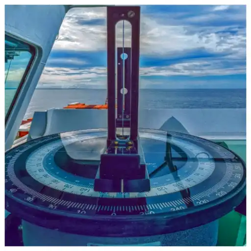
If the Earth’s natural magnetic field doesn’t spin compasses wildly, why do maritime logs occasionally mention broken instruments?
The explanation sits right on board the vessel.
Mariners distinguish between two key navigational terms:
- Variation (Declination): The global offset caused by Earth’s magnetic field.
- Deviation: Local compass error caused by magnetic metals onboard the ship itself.
Steel hulls, heavy diesel engines, radio transmitters, and wiring harnesses create localized magnetic interference. A compass placed near a ship’s engine block will point toward the engine rather than north.
Navigators install small iron spheres (called Kelvin’s balls) alongside ship compasses to cancel out this internal metal interference. If an electrical short occurs or a metal crate shifts during a storm, the compass needle wanders immediately. Early investigators often misdiagnosed these equipment faults as “mysterious ocean forces“.
Why modern GPS rendered the magnetic anomaly obsolete
Do modern ships still worry about getting lost in the Bermuda Triangle because of compass errors?
Not anymore. Navigation technology has evolved far beyond basic magnetic needles.
Modern aircraft and ocean freighters rely on multi-layered navigation systems that run simultaneously:

- Global Positioning System (GPS): Receives radio signals from satellite constellations orbiting thousands of miles above Earth, pinpointing exact latitude and longitude down to the inch.
- Inertial Navigation Systems (INS): Uses built-in gyroscopes and accelerometers to track motion independent of magnetic fields or radio signals.
- Digital Fluxgate Compasses: Electronic sensors that measure Earth’s magnetic field in three dimensions while computer software automatically corrects for magnetic declination.
Every five years, NOAA and the British Geological Survey release an updated World Magnetic Model (WMM). This global mathematical model maps Earth’s magnetic field changes down to the kilometer. Modern digital navigation software updates automatically using this data.
A pilot flying through the Bermuda Triangle today doesn’t calculate magnetic declination on paper charts. Onboard computers handle the math in real time.
Official stance: NOAA and the U.S. coast guard
What do official marine agencies say about the Bermuda Triangle mystery?
Both NOAA and the U.S. Coast Guard treat the Bermuda Triangle as an ordinary stretch of ocean.
“There is no evidence that mysterious disappearances occur with any greater frequency in the Bermuda Triangle than in any other large, well-traveled area of the ocean.”
— U.S. National Oceanic and Atmospheric Administration (NOAA)
The U.S. Coast Guard notes that the Bermuda Triangle is one of the most heavily trafficked waterways in the world. Thousands of cruise ships, cargo vessels, private yachts, and commercial airliners cross it daily without incident.
When accidents do happen in the region, investigators attribute them to well-documented environmental hazards:
- The Gulf Stream: A powerful ocean current moving like a fast river through the Atlantic, quickly sweeping away wreck debris.
- Sudden Microbursts: Unexpected localized storms that dump heavy rain and knock down light aircraft.
- Shallow Caribbean Shoals: Hidden sandbars and coral reefs that ground ships unaware of water depths.
- Human Error: Fuel mismanagement and poor judgment during adverse weather conditions.
Myth vs Reality breakdown
| Feature / Question | Popular Mystery Lore | Scientific & Historical Fact |
| Are there magnetic anomalies? | Yes, a localized magnetic field spins dials | No, geomagnetic surveys show normal crustal fields |
| Why did compasses misbehave historically? | Mysterious alien energy or vortex | Unadjusted magnetic declination across the Agonic Line |
| Is the Bermuda Triangle officially recognized? | Yes, marked as a danger zone | No, the U.S. Board on Geographic Names does not list it |
| Are disappearances statistically higher? | Yes, ships vanish at alarming rates | No, loss rates match any heavily trafficked ocean sector |
| How do modern ships navigate it? | They risk instrument failure | Satellite GPS and WMM auto-correct magnetic offsets |
Quick Faq’s
Does the Agonic Line still pass through the Bermuda Triangle?
No. Earth’s magnetic field constantly shifts. Over the past 100 years, the Atlantic agonic line drifted westward and currently passes through the Gulf of Mexico and North America.
What is the difference between magnetic declination and deviation?
Magnetic declination is the angle between True North and Magnetic North caused by Earth’s magnetic field. Deviation is compass error caused by magnetic metals or electronics onboard your ship or airplane.
Can methane bubbles sink ships in the Bermuda Triangle?
While methane hydrate deposits exist under ocean floors globally, NOAA has found no evidence of massive methane eruptions causing ship sinkings in the Bermuda Triangle.

