
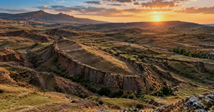
A boat-shaped mound resting in the rugged foothills of eastern Turkey has stoked humanity’s wildest archaeological dreams for nearly seven decades. This month, an international research team punched deep into the dirt with heavy machinery to test the legend once and for all. Before anyone rewrites human history, we need to look past the breathless viral posts and examine what the rocks actually reveal.
A Strange Shape on the Horizon
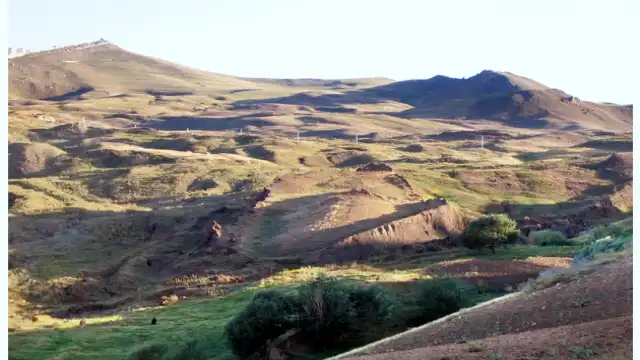
Imagine flying high above the remote mountains of eastern Turkey in 1959. Below you lies a barren landscape of craggy peaks, slipping mud, and dry scree. Suddenly, down in the dirt, you spot an outline that stops you mid-breath: a massive, symmetrical ridge tapering at both ends, looking exactly like the hull of a giant ocean ship frozen in stone.
That is precisely how Turkish Air Force Captain İlhan Durupınar discovered what we now call the boat shaped formation dogubayazit. Located roughly 19 miles south of the snow-capped peak of Greater Mount Ararat, the site immediately fired up global imaginations. Could this be the legendary craft described in the ancient book of Genesis?
The math certainly made people jump. The mound measures roughly 515 feet long — somewhere between 157 and 164 meters. Convert that into ancient biblical units, and you get remarkably close to 300 cubits, the exact measurement ancient scribes recorded for the Ark. For early adventurers, the puzzle felt solved on the spot. Decades of amateur digs, sensational magazine spreads, and late-night documentaries turned the formation into ground zero for amateur relic hunters.
Yet, looks can be deceiving. A cloud can look like a rabbit, but that does not mean it has ears and fur. Does the ridge really shelter petrified ancient decks, or did Mother Nature simply sculpt a dramatic decoy?
The 2026 Drilling Campaign
After decades of bitter debates between true believers and skeptical university professors, the site recently moved from playground theories to serious laboratory testing. A ninety-day expedition brought together twenty scientists across five countries to tackle the mystery with modern equipment. Authorized by the Turkish Ministry of Environment, Urbanization and Climate Change, the project represents a rare joint venture between academic researchers and independent survey specialists.
The project gathered international attention when the team launched deep subterranean sampling. As detailed in a dispatch published by GlobeNewswire, crews began systematic durupinar noahs ark core drilling aimed at pulling physical soil and rock cylinders out of the ground. Drilling reached depths down to 18 meters inside and outside the perimeter.
Things took a dramatic turn when the heavy drill bit plunged down between four and five meters. Without warning, the steel rig shuddered, groaned, and shattered.
The drill bit hit something shockingly hard — harder than the surrounding limestone. Exploration leaders immediately wondered whether the rig had collided with dense petrified wood from an ancient hull.
The technology deployed here is not your everyday shovel-and-brush archaeology. The expedition brought in specialized subsurface radar known as EarthRadar, operated by veteran defense scientist Dr. Khosrow Bakhtar alongside project vice president Andrew Jones. This specialized ground-penetrating radar peered up to 70 meters below the surface, mapping underground anomalies that the field crew interpreted as possible parallel walls, cavities, and interior chambers.

To investigate those empty subterranean pockets, researchers brought in a specialized crawler robot named “Gopher”. The goal? Slip the mini-robot down the boreholes to grab close-up video and snatch internal samples from spaces human hands cannot reach, a development recently tracked by Ground News.
What Cenker Atila’s team is actually looking for
Whenever internet gossip goes wild, cool scientific heads have to step into the room. That voice of reason belongs to Prof. Dr. Cenker Atila, an archaeologist at Sivas Cumhuriyet University who leads the scientific field mission.
Speaking plainly to reporters, Atila pumped the brakes on runaway claims. He emphasized that internet banners declaring Noah’s Ark has officially been found are flat-out misleading. His team is not hunting relics to prove legends; they are following standard geological and archaeological procedures.
The reality of this research is methodical, quiet, and dirty:
- Crews logged exact satellite GPS positions, 3D laser scans, and high-altitude drone mapping across every inch of the formation.
- Field teams gathered roughly 1,000 distinct core and soil samples from 150 separate boreholes across the ridge and surrounding valley.
- All gathered specimens were sealed and shipped to specialized laboratories in Ankara.
- Chemists are running carbon tests, organic matter evaluations, and thin-slice mineral exams to see whether any man-made materials, preserved timber, or animal bones exist under the surface.
According to Atila, definitive lab answers will take several months to finalize. Scientific conclusions require peer review, replicable lab data, and hard chemical proof. Until those test tubes finish reacting, any public announcement claiming a lost ship rests in the soil is pure guesswork.
As noted in a detailed analysis by IBTimes UK, independent archaeologists caution that anomalous readings on a computer screen do not automatically equal man-made carpentry.
The Geological Reality
Why do mainstream geologists stay so skeptical when amateur explorers get so excited? Because geologists have spent decades studying rock folds, and they know nature can build striking illusions without any human help.
Decades ago, geologists including Dr. Lorence Collins and Turkish geological researchers thoroughly investigated the durupinar formation noahs ark debate. Their diagnosis was straightforward: the site is a textbook natural geological feature known as a doubly-plunging syncline.
What does that fancy phrase mean? Picture a giant stack of soft clay sheets, limestone layers, and volcanic dirt lying flat on the ground. When continents slowly grind into one another, enormous tectonic forces squeeze those flat rock sheets from both sides. The rock buckles like an accordion, bending downward into a bowl or trough. When that bent fold tilts downward at both ends, geologists call it a doubly-plunging syncline.
Slice across that folded rock through millions of years of rainfall, and what pops out at the surface? A smooth, pointed, canoe-like oval.
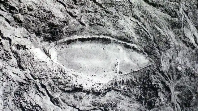
Surrounding this rock formation is an active, muddy debris flow. For millennia, wet clay, broken stones, and gravel have oozed down the hillside like a glacier made of mud. Right in the middle of this muddy conveyor belt sits a resistant block of dense marine limestone and ophiolite (ancient oceanic crust shoved up into the mountains by shifting tectonic plates).
As the soft mud flows around this stubborn block of hard rock, it carves away the edges, smoothing the sides into a sleek teardrop shape. Engineers call this hydrodynamic shaping. Wind does the same thing to desert rocks, shaping aerodynamic ridges called yardangs. River currents carve islands into pointed boat hulls every single day.
The hill looks like a ship for the exact same reason a river pebble feels smooth: friction and flowing debris naturally taper resistant objects.
Shattered Drill Bits and Radar Ghosts
When an expedition announces a broken drill bit or striking underground radar lines, our brains instantly picture wooden deck beams and hidden cabins. Let’s break down those claims with common sense.
Did a shattered drill bit hit Noah’s petrified gopher wood?
Shattering a drill bit during geological drilling happens all the time. Eastern Anatolia is an intensely active volcanic zone dominated by basalt, andesite, and ancient marine deposits. It takes very little to destroy an industrial core bit if you slam into a dense nodule of chert (flint), a chunk of quartzite, or an ultra-hard basalt boulder embedded in softer mud. Chert nodules score a 7 on the Mohs mineral hardness scale — harder than normal tool steel. Proving that an underground obstacle is petrified timber requires pulling up structural wood cells, not simply buying a replacement drill head.
What about the straight lines seen on ground-penetrating radar?
Ground-penetrating radar works by sending pulses of electromagnetic radio waves into the earth. Whenever that wave hits a boundary where density or moisture changes, it bounces back up to a receiver.
Geological formations are packed with natural joint sets, fracture zones, and bedding planes. When rocks crack under tectonic stress, they frequently snap along neat, intersecting 90-degree angles. To an eager explorer looking at an uncalibrated computer screen, those perpendicular fractures look like corridors, interior rooms, and rib timbers. To a field geologist, they look like ordinary jointing patterns found in folded sedimentary strata around the globe. Our brains love finding familiar patterns in random noise — a mental quirk called pareidolia.
Does high organic soil content mean cargo and living wood?
Expedition updates noted higher organic carbon counts inside certain drilled soil samples. Does that prove an ancient wooden zoo rotted there? Not quite.
Ancient lakebeds, swampy marshes, and buried peat layers exist throughout the region. Decaying plant leaves, ancient algal blooms, and microscopic marine life trapped in muddy limestone regularly produce organic-rich sediments and bituminous shales. Finding carbon in dirt tells you life existed nearby; it does not tell you someone hammered it into a three-deck barge.
The Mount Ararat Geography Puzzle
Geography presents another massive headache for the legend. Popular culture talks about Noah’s Ark landing right on the icy peak of Mount Ararat.
The actual Hebrew text of Genesis says the vessel rested on the mountains of Ararat — a plural phrase referring to the ancient Kingdom of Urartu. That kingdom covered thousands of square miles across modern Turkey, Armenia, and Iran.
The Durupınar site sits roughly 19 miles south of Greater Mount Ararat. In fact, locating the vessel on Mount Ararat itself makes little geological sense. Greater Mount Ararat is a towering stratovolcano built up by massive eruptions long after the earliest humans lived in Anatolia. Any ancient wooden object sitting on that mountain would have been burned to cinder by molten lava or pulverized into splinters by creeping summit glaciers. That harsh reality is why researchers continually shift their eyes south toward the lower sedimentary ridges of Doğubayazıt.
What would real archaeological proof actually look like?
If radar pictures and broken drills cannot prove an ancient ship, what could? Science requires strict physical standards before verifying any discovery that could overturn world history.
To move beyond natural geology, cenker atila durupinar research and independent laboratories would need to produce unmistakable physical fingerprints:
- Carpentry Marks and Joinery: Recovered timber must display clear human craftsmanship — chisel gouges, saw marks, mortise-and-tenon joints, or bored dowel holes. Natural fossilized logs do not come with square pegs and fitted joints.
- Manufactured Fasteners: Finding metal rivets or binding pitch requires chemical proof of human smelting or synthetic blending. Natural iron-manganese concretions (which often look like rusted metal spikes) cannot substitute for actual metallurgy.
- Non-Native Timber Species: If drilling extracts cedar, cypress, or white oak species arranged structurally inside a region dominated by local brush and mountain scree, that would grab serious academic attention.
- Cultural Artifacts: Ships carry human life. A genuine archaeological site holds broken ceramic cookware, woven ropes, butchered animal bones with cut marks, or domesticated seed caches packed into clear habitation layers.
- Clean Holocene Carbon Dates: The extracted organic matter must date consistently to the Holocene epoch (within the window of human civilization), rather than millions of years back into the Miocene or Cretaceous periods.
Unless peer-reviewed papers verify those criteria, the mound remains an interesting natural formation, nothing more.
Staying Grounded in the Search for Truth
Why are people so eager to see a biblical ship carved into these Turkish hills? Great flood stories exist in almost every ancient culture, from the Epic of Gilgamesh in Mesopotamia to tales across early Asia and the Americas. The idea that an ancient family survived a ruined world touches something deeply human inside us. We desperately want the stories of our ancestors to be tangible things we can reach out and touch.
Hope alone cannot turn limestone into timber. When scientific teams run permitted core drilling and lower robots into deep cavities, they do what real science should always do: put hypotheses to the test.
If the Ankara laboratory reports reveal nothing more than natural clay, calcified marl, and volcanic rock, the Durupınar formation will still stand as one of the most stunning geological sculptures on Earth. And if those core tubes pull up shaped cedar planks bearing the marks of ancient bronze tools? Well, that is a discovery the entire scientific world will be eager to verify. Until then, keep your curiosity bright, your questions sharp, and your trust anchored in verifiable facts.

